geography
|
Lesotho is located in the middle of Southern and South Africa, although politically independent from the latter. Today the only way to reach Lesotho is therefore via South Africa and from there either by air into Maseru, or by car entering the country through any one of its borders with South Africa.
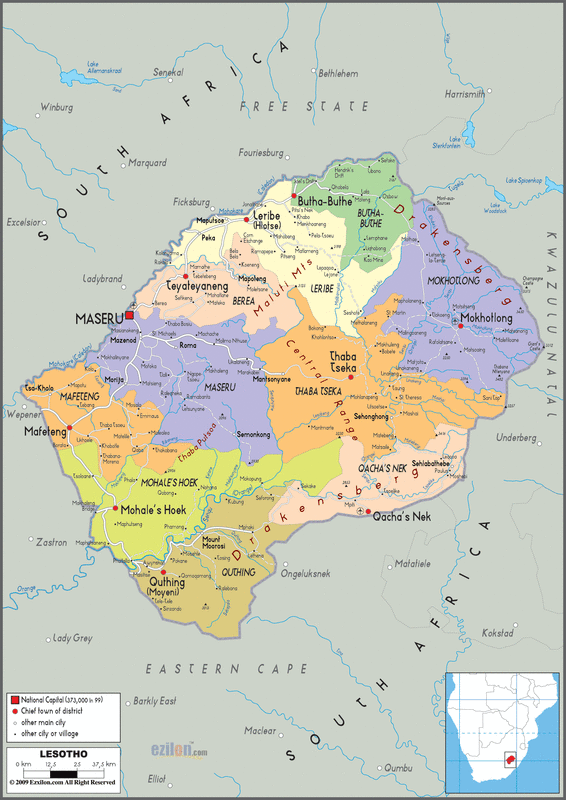
Lesotho’s terrain is mainly high veld with plateaus and mountains. It is thought to be the highest country in the world, due to its average altitude being far higher than that of others around the world. Its lowest points are to be found at altitudes in excess of 1000 metres, whilst its highest points raise to in excess of 3, 000 metres. Most of Lesotho is in the Drakensberg and Maluti mountain ranges, and it covers an area of some 30, 335 Sq km. DISTRICTS Please note that district names are in italics. Cities and towns are underlined. Maseru Maseru As can be determined by its name, Maseru is not only the capital City of Lesotho but also the centre of the district by the same name. Located in the lowlands to the west of the country, it is to be found on the banks of the Caledon (“Mohokare” in Sesotho) river. It was established as a small trading post in 1869, and is close to the Maseru Bridge border post with South Africa. Being the capital city, it serves as the customs and immigration gateway to South Africa, although most of the same services are now to be found at the many other border crossings. Maseru is the seat of government and hosts the King’s primary (official) residence. It has a population of approximately 200, 000 (2006 census). Lesotho’s parliament and government are also based in Maseru, as are all the representatives of major organisations, Embassies, and High Commissions of foreign governments. Most of Lesotho’s industrial and commercial activity is also to be found in Maseru, including banking, manufacturing and assembly plants, International and local hotels and casinos, entertainment centres, as well as shopping centres with the major Southern African department stores all represented here. Matsieng Matsieng is based in the district of Maseru, and is home to the King’s traditional residence. Roma The National University of Lesotho is located in the town now known as Roma, some 35 kilometres outside the capital, Maseru. Roma was initially a Roman Catholic mission (hence its name), and grew to become the country’s centre of education. Over and above the university, Roma is home to several secondary schools, seminaries and convents. It is also home to one of Lesotho’s main hospitals. Thaba Bosiu Thaba Bosiu is also located in the district of Maseru, some 25 kilometres to the east of the capital, Maseru. It is the place where King Moshoeshoe I, the first ruler of the Basotho originally established a stronghold, and today houses the cemetery of the Kings of Lesotho. The name “Thaba Bosiu” means the “mountain of the night”, because it is said that whilst a hill in the daytime, it rises to become a mountain in the dark of the night. Thaba Bosiu is probably Lesotho’s most important historical centre, and houses a visitors’ information centre. It is a ‘must see’ for any visitor to the country. Morija Morija is home to the Morija Museum and Archives centre, Lesotho’s largest and most comprehensive museum. Located some 40 kilometres from Maseru, it is the place where the Europeans first established themselves on arrival in Lesotho. The museum itself is a place of interest and not to be missed by visitors to Lesotho. www.morijafest.co.ls Berea Teyateyaneng To the north of Maseru is the district of Berea, whose capital is Teyateyaneng or “TY” as it is commonly known. It is known as the centre of Arts and crafts in Lesotho, housing numerous craft markets and co-operatives producing high quality mohair products. These include “Helang Basali” (“come on ladies”), Setsoto Designs, and “Hatooa Mose Mosali” (“get of your dress, woman”). Visitors are encouraged to visit these for some of the highest quality mohair products in the world, all made the traditional way. The district itself has a long and varied history of human habitation dating back to the 1820s. The first assistant commissioner arrived in the area in the 1880s, with a number of missions being established there soon thereafter. Leribe Hlotse Hlotse is found to the again of the district of Leribe and is its capital city. It is located on the banks of the river after which it was named, and is found near the South African Free State town of Ficksburg. The main route to Katse Dam in the highlands passes through Hlotse. It has grown due to the high traffic of construction material being transported up to Katse during the construction of the dam in the late 1980s and early 1990s, through the border at Maputsoe, the district’s other main town. Hlotse was the location of a small fort built in the 1870s, which the resident magistrate and missionaries were permitted to build by the local chief. Today, only the Major Bell’s Tower, a part of that original fort remains as a landmark on its main street. The district of Leribe is also one of the sites of Dinosaur footprints, of which there are several in Lesotho, located a few kilometres outside Hlotse at Tsikoane village. Peka Maputsoe Butha Buthe Butha Buthe As with some of the other districts, Butha Buthe is the capital city of the district of the same name. It is Lesotho’s second largest city, with a bustling town centre, government and other administrative buildings, retail outlets and a number of hotels. It also has one of Lesotho’s larger Mosques as a result of its sizeable muslim community. It is located some 125 kilometres north of Maseru at the beginning of the northern ascent into the Maluti Mountains, and from here the Tsehlanyane National Park is best accessed. Butha Buthe too has benefited immensely as a result of the Highlands Water Project, with a suburb (Likileng) being established to house the large workforce working on the project. Mokhotlong Mokhotlong Once again, this capital city, found in the mountains to north-east of Lesotho, bears the same name as the district it is the centre of. It is the main town in the highlands of Lesotho, with access to South Africa being via the picturesque and dramatic Sani Pass. From Mokhotlong one is also able to reach the highest point in the Southern Africa at Thabana Ntlenyana (3,482m). It is also from here that one gets to the Sehlabathebe National Park. Thaba Tseka Thaba Tseka Thaba Tseka is located in the mountains of Lesotho and almost directly in the middle of the country. It is a relatively new town, being established as a district centre in the early 1980s. It too has seen tremendous growth due to the construction of the Katse Dam, and is on the road between Maseru and Katse. Mafeteng Mafeteng Found further to the south of Matsieng and Morija is Mafeteng, the capital of the district that bears the same name. It is located some 80 kilometres to the South of Maseru, and not far from the Van Rooyen’s Gate border crossing into the Free State in South Africa. Mafeteng is a former Garrison town, but which developed as an important centre of Lesotho’s literacy history. Mafeteng has grown rapidly since the country attained its independence, and is now a bustling town centre supporting the surrounding communities. It is also the site of the Lesotho Pharmaceutical Corporation, a subsidiary of the Lesotho National Development Corporation (“LNDC”) (www.lndc.org.za), and an employer of numerous citizens of the town. Mohale's Hoek Mohale’s Hoek As one continues in an anti-clockwise direction or further south from Mafeteng, one reaches Mohale’s Hoek, once again the centre of the district that goes by the same name. Mohale’s Hoek was named after the younger brother of King Moshoeshoe I who gave the land to the British, from where they ran their administrative affairs. Qacha's Nek Qacha's Nek It is said that Qacha’s Nek was established in the late 19th century as a mission station and is some 1980m above sea level. From here one can also gain access to the Sehlabathebe National Park, the country’s first national park. Quthing Quthing At the southernmost point of Lesotho is the town of Quthing. It is said to have been established in the late 19th century, abandoned and subsequently re-built to what we have today. It is also known as ‘Moyeni’, meaning “the place of the wind”. Some 5 kilometres from Quthing, one finds the Masitise Cave House Museum, an old mission that was extraordinarily built into a San Rock shelter in the mid-1800s. Quthing is also home to a number of sites of Dinosaur footprints and a San paintings cave nearby. |

Advertise Here
|
